Perdeu a senha?
Novo usuário? Criar uma conta
Lizard fish, Philippines. Photo by Stephane Rochon.
Aprecie e contribua!
| Achar os melhores sites |
|
|
 Namibia
África
Localização: Southern Africa, bordering the South Atlantic Ocean, between Angola and South Africa
Coordenadas geográficas: 22° 0' S, 17° 0' E
Costa: 1,572 km km
Clima: desert; hot, dry; rainfall sparse and erratic
Relevo:
Cimeiras:
Riscos naturais: prolonged periods of drought. very limited natural fresh water resources; desertification; wildlife poaching; land degradation has led to few conservation areas
Moeda: Namibian dollar (NAD); South African rand (ZAR)
População:
Línguas: English 7% (official), Afrikaans common language of most of the population and about 60% of the white population, German 32%, indigenous languages 1% (includes Oshivambo, Herero, Nama)
Capital:
Divisão administrativa:
Mais informações
| Jan | Feb | Mar | Apr | May | Jun | Jul | Aug | Sep | Oct | Nov | Dec | |
|---|---|---|---|---|---|---|---|---|---|---|---|---|
| Climate | ||||||||||||
| Air temp. | ||||||||||||
| Water temp. | ||||||||||||
| Equipment | ||||||||||||
| Best season | ||||||||||||
Você quer acrescentar outras informações sobre Namibia? Diga-nos...
Este mapa é interactivo! Use os controles para fazer zoom ou para se deslocar.
- mergulhos (0)
- viagens (0)
- Fotos (2)
- Vídeos (0)
- Compartilhe
- Favoritos
-
Os seus sítios favoritos e as futuras listas de spots
Sites de mergulho
| Sites de mergulho (2) | Qualidade | Profundidade média | Profundidade máxima | Experiência | Tipo de mergulho | ||
|---|---|---|---|---|---|---|---|
| Lake Guinas | - / - | 65 m | 130 m | Kamikazes/Trimix | 


|
||
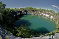
| Otjikoto Lake | 2 / - | 45 m | 58 m | Kamikazes/Trimix |
|
 Comentários
Seja o(a) primeiro(a) a fazer um comentário sobre este país
Erros, Reacções
Se você quer adicionar novas informações ou se você encontrou erros nesta página, Envie as suas observações