Este mapa é interactivo! Use os controles para fazer zoom ou para se deslocar.
Acesso
|
English (Traduzir este texto em Português): Saranda bay
English (Traduzir este texto em Português): Saranda bay
Saranda bay
English (Traduzir este texto em Português): Saranda bay
English (Traduzir este texto em Português): Saranda bay
English (Traduzir este texto em Português): Saranda bay
English (Traduzir este texto em Português): Saranda bay
English (Traduzir este texto em Português): Saranda bay
English (Traduzir este texto em Português): Saranda bay
Como?
Distância
Fácil de encontrar?
|
|
Características do local
Profundidade média 15 m / 49.2 ft
Profundidade máxima 30 m / 98.4 ft
Correnteza
Visibilidade
Qualidade
Qualidade do sitio
Experiência
Interesse bio
Mais detalhes
Cheio durante a semana
Cheio no fim de semana
Tipo de mergulho
Actividades de mergulho
Perigos
Informações suplementares
English (Traduzir este texto em Português): Inside the Bay of Saranda there lies an Italian cargoship. It was sunk during the II World War by German Bombers on their way back from an attack on the Balkans. Traces of the bombs can still be seen on the ships sides! The vessel lies on its port side on the sandy bed at a maximum depth of 18m just 300m away from the shore. At the shallowest point the ship is just 3m form the surface and is marked with a bouy. The ship is roughly 115m long. It is marked above water by a Cardinal bouy signalling danger. Visibility underwater is good about 20m.
English (Traduzir este texto em Português): Inside the Bay of Saranda there lies an Italian cargoship. It was sunk during the II World War by German Bombers on their way back from an attack on the Balkans. Traces of the bombs can still be seen on the ships sides! The vessel lies on its port side on the sandy bed at a maximum depth of 18m just 300m away from the shore. At the shallowest point the ship is just 3m form the surface and is marked with a bouy. The ship is roughly 115m long. It is marked above water by a Cardinal bouy signalling danger. Visibility underwater is good about 20m.
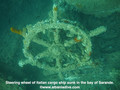
Inside the Bay of Saranda there lies an Italian cargoship. It was sunk during the II World War by German Bombers on their way back from an attack on the Balkans. Traces of the bombs can still be seen on the ships sides! The vessel lies on its port side on the sandy bed at a maximum depth of 18m just 300m away from the shore. At the shallowest point the ship is just 3m form the surface and is marked with a bouy. The ship is roughly 115m long. It is marked above water by a Cardinal bouy signalling danger. Visibility underwater is good about 20m.
English (Traduzir este texto em Português): Inside the Bay of Saranda there lies an Italian cargoship. It was sunk during the II World War by German Bombers on their way back from an attack on the Balkans. Traces of the bombs can still be seen on the ships sides! The vessel lies on its port side on the sandy bed at a maximum depth of 18m just 300m away from the shore. At the shallowest point the ship is just 3m form the surface and is marked with a bouy. The ship is roughly 115m long. It is marked above water by a Cardinal bouy signalling danger. Visibility underwater is good about 20m.
English (Traduzir este texto em Português): Inside the Bay of Saranda there lies an Italian cargoship. It was sunk during the II World War by German Bombers on their way back from an attack on the Balkans. Traces of the bombs can still be seen on the ships sides! The vessel lies on its port side on the sandy bed at a maximum depth of 18m just 300m away from the shore. At the shallowest point the ship is just 3m form the surface and is marked with a bouy. The ship is roughly 115m long. It is marked above water by a Cardinal bouy signalling danger. Visibility underwater is good about 20m.
English (Traduzir este texto em Português): Inside the Bay of Saranda there lies an Italian cargoship. It was sunk during the II World War by German Bombers on their way back from an attack on the Balkans. Traces of the bombs can still be seen on the ships sides! The vessel lies on its port side on the sandy bed at a maximum depth of 18m just 300m away from the shore. At the shallowest point the ship is just 3m form the surface and is marked with a bouy. The ship is roughly 115m long. It is marked above water by a Cardinal bouy signalling danger. Visibility underwater is good about 20m.
English (Traduzir este texto em Português): Inside the Bay of Saranda there lies an Italian cargoship. It was sunk during the II World War by German Bombers on their way back from an attack on the Balkans. Traces of the bombs can still be seen on the ships sides! The vessel lies on its port side on the sandy bed at a maximum depth of 18m just 300m away from the shore. At the shallowest point the ship is just 3m form the surface and is marked with a bouy. The ship is roughly 115m long. It is marked above water by a Cardinal bouy signalling danger. Visibility underwater is good about 20m.
English (Traduzir este texto em Português): Inside the Bay of Saranda there lies an Italian cargoship. It was sunk during the II World War by German Bombers on their way back from an attack on the Balkans. Traces of the bombs can still be seen on the ships sides! The vessel lies on its port side on the sandy bed at a maximum depth of 18m just 300m away from the shore. At the shallowest point the ship is just 3m form the surface and is marked with a bouy. The ship is roughly 115m long. It is marked above water by a Cardinal bouy signalling danger. Visibility underwater is good about 20m.
English (Traduzir este texto em Português): Inside the Bay of Saranda there lies an Italian cargoship. It was sunk during the II World War by German Bombers on their way back from an attack on the Balkans. Traces of the bombs can still be seen on the ships sides! The vessel lies on its port side on the sandy bed at a maximum depth of 18m just 300m away from the shore. At the shallowest point the ship is just 3m form the surface and is marked with a bouy. The ship is roughly 115m long. It is marked above water by a Cardinal bouy signalling danger. Visibility underwater is good about 20m.
 Comentários
Mostrar tudo (0)...
Seja o(a) primeiro(a) a fazer um comentário sobre este país
Erros, Reacções
Você pode editar esta página para corrigir os erros e acrescentar novas informações. Se você tem outros comentários sobre esta página, Envie as suas observações
Wannadive.net 24/24
Wannadive.net no seu telemóvel

Boletim Todas as notícias por e-mail
 Italian Freighter Probitas