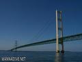
English (Traduzir este texto em Português): The Straits of Mackinac Shipwreck Preserve is a 148 mi² (383 km²) state preserve in and around the Straits of Mackinac. The preserve is divided in two by the Mackinac Bridge. The waters of the preserve include the waters offshore from Mackinaw City and St. Ignace, as well as all or part of the shorelines of Bois Blanc Island, Mackinac Island, Round Island, and St. Helena Island.
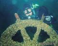
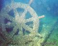
The preserve contains at least eleven identified wrecks. Frequent fog and congested shipping added to the count of shipwrecks in the Straits area. Half a dozen lighthouses in and around the preserve testify to the dangers that existed prior to the invention of radar in the 1940s. Tragedies have continued, however. One modern wreck within the boundaries of the preserve is the Cedarville, a limestone lake freighter that sank in 1965 after a collision.
Divers also visit underwater formations of Mackinac breccia near Mackinac Island; one such formation, the Rock Maze, is offshore from Arch Rock. Further east off Arch Rock, a drowned, 100-foot-high (30 m) waterfall formation, Mackinac Falls, was discovered in August 2007.
Source: Wikipedia.org
English (Traduzir este texto em Português): The Straits of Mackinac Shipwreck Preserve is a 148 mi² (383 km²) state preserve in and around the Straits of Mackinac. The preserve is divided in two by the Mackinac Bridge. The waters of the preserve include the waters offshore from Mackinaw City and St. Ignace, as well as all or part of the shorelines of Bois Blanc Island, Mackinac Island, Round Island, and St. Helena Island.
The preserve contains at least eleven identified wrecks. Frequent fog and congested shipping added to the count of shipwrecks in the Straits area. Half a dozen lighthouses in and around the preserve testify to the dangers that existed prior to the invention of radar in the 1940s. Tragedies have continued, however. One modern wreck within the boundaries of the preserve is the Cedarville, a limestone lake freighter that sank in 1965 after a collision.
Divers also visit underwater formations of Mackinac breccia near Mackinac Island; one such formation, the Rock Maze, is offshore from Arch Rock. Further east off Arch Rock, a drowned, 100-foot-high (30 m) waterfall formation, Mackinac Falls, was discovered in August 2007.
Source: Wikipedia.org
The Straits of Mackinac Shipwreck Preserve is a 148 mi² (383 km²) state preserve in and around the Straits of Mackinac. The preserve is divided in two by the Mackinac Bridge. The waters of the preserve include the waters offshore from Mackinaw City and St. Ignace, as well as all or part of the shorelines of Bois Blanc Island, Mackinac Island, Round Island, and St. Helena Island.
The preserve contains at least eleven identified wrecks. Frequent fog and congested shipping added to the count of shipwrecks in the Straits area. Half a dozen lighthouses in and around the preserve testify to the dangers that existed prior to the invention of radar in the 1940s. Tragedies have continued, however. One modern wreck within the boundaries of the preserve is the Cedarville, a limestone lake freighter that sank in 1965 after a collision.
Divers also visit underwater formations of Mackinac breccia near Mackinac Island; one such formation, the Rock Maze, is offshore from Arch Rock. Further east off Arch Rock, a drowned, 100-foot-high (30 m) waterfall formation, Mackinac Falls, was discovered in August 2007.
Source: Wikipedia.org
English (Traduzir este texto em Português): The Straits of Mackinac Shipwreck Preserve is a 148 mi² (383 km²) state preserve in and around the Straits of Mackinac. The preserve is divided in two by the Mackinac Bridge. The waters of the preserve include the waters offshore from Mackinaw City and St. Ignace, as well as all or part of the shorelines of Bois Blanc Island, Mackinac Island, Round Island, and St. Helena Island.
The preserve contains at least eleven identified wrecks. Frequent fog and congested shipping added to the count of shipwrecks in the Straits area. Half a dozen lighthouses in and around the preserve testify to the dangers that existed prior to the invention of radar in the 1940s. Tragedies have continued, however. One modern wreck within the boundaries of the preserve is the Cedarville, a limestone lake freighter that sank in 1965 after a collision.
Divers also visit underwater formations of Mackinac breccia near Mackinac Island; one such formation, the Rock Maze, is offshore from Arch Rock. Further east off Arch Rock, a drowned, 100-foot-high (30 m) waterfall formation, Mackinac Falls, was discovered in August 2007.
Source: Wikipedia.org
 Straits of Mackinac Shipwreck Preserve


 Fotos
Fotos