Perdeu a senha?
Novo usuário? Criar uma conta
Lizard fish, Philippines. Photo by Stephane Rochon.
Aprecie e contribua!
| Achar os melhores sites |
|
|
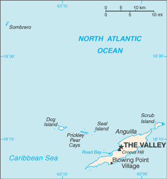
 Anguilla
América Central
Localização: Caribbean, islands between the Caribbean Sea and North Atlantic Ocean, east of Puerto Rico
Coordenadas geográficas: 18° 15' N, 63° 10' W
Costa: 61 km km
Clima: tropical; moderated by northeast trade winds
Relevo: flat and low-lying island of coral and limestone
Cimeiras: lowest point: Caribbean Sea 0 m
highest point: Crocus Hill 65 m
Riscos naturais: frequent hurricanes and other tropical storms (July to October)
Moeda: East Caribbean dollar (XCD)
População: 13,677 (July 2007 est.)
Línguas: English (official)
Capital: The Valley
Divisão administrativa: none (overseas territory of the UK)
Mais informações
| Jan | Feb | Mar | Apr | May | Jun | Jul | Aug | Sep | Oct | Nov | Dec | |
|---|---|---|---|---|---|---|---|---|---|---|---|---|
| Climate | ||||||||||||
| Air temp. | ||||||||||||
| Water temp. | ||||||||||||
| Equipment | Don't know | Don't know | Don't know | Don't know | Don't know | Don't know | Don't know | Don't know | Don't know | Don't know | Don't know | Don't know |
| Best season | ||||||||||||
Mapa
Você quer acrescentar outras informações sobre Anguilla? Diga-nos...
Este mapa é interactivo! Use os controles para fazer zoom ou para se deslocar.
- mergulhos (76)
- viagens (10)
- Fotos (1)
- Vídeos (0)
- Compartilhe
- Favoritos
-
Os seus sítios favoritos e as futuras listas de spots
Sites de mergulho
| Sites de mergulho (21) | Qualidade | Profundidade média | Profundidade máxima | Experiência | Tipo de mergulho | ||
|---|---|---|---|---|---|---|---|
| Angel Reef | - / - | 15 m | 19.8 m | Para todos os níveis | 
|
||
| Anguillita | - / - | 10.7 m | 18.3 m | CMAS * / OW | 
|
||
| Beacon | - / - | 15 m | 21.3 m | Para todos os níveis |
|
||
| Blowing Rock | - / - | 9.1 m | 12.2 m | Para todos os níveis | 

|
||
| Captain Turtle | - / - | 15 m | 19.8 m | Para todos os níveis |
|
||
| Crystal Reef | - / - | 16.5 m | 25 m | CMAS * / OW |
|
||
| Dog Island | - / - | 20 m | 30.5 m | CMAS ** / AOW | 
|
||
| Frenchman's Reef | - / - | 20 m | 30.5 m | CMAS * / OW |
|
||
| Lobster Reef | - / - | 18 m | 30.5 m | Para todos os níveis |
|
||
| MV Catheley H Wreck | - / - | 10.7 m | 18.3 m | Para todos os níveis |
|
||
| MV Commerce | - / - | 20 m | 25 m | CMAS * / OW | 
|
||
| MV Ida Maria Wreck | - / - | 12.2 m | 18.3 m | CMAS * / OW |
|
||
| MV Oosterdiep | - / - | 24.4 m | 25 m | Para todos os níveis |
|
||
| MV Sarah | - / - | 20 m | 25.9 m | CMAS * / OW |
|
||
| No Name Reef | 1 / - | 12.2 m | 16.8 m | Para todos os níveis |
|
||
| Prickly Pear | - / - | 5 m | 17 m | Para todos os níveis |
|
||
| Sea Fan | - / - | 10 m | 12.2 m | Para todos os níveis |
|
||
| Shoal Bay Reef | - / - | 18 m | 25.9 m | Para todos os níveis |
|
||
| Teigland | - / - | 15 m | 21 m | Para todos os níveis |
|
||
| The Garden | - / - | 25 m | 34.1 m | CMAS * / OW |
|
||
| West Cay | - / - | 15 m | 32 m | CMAS * / OW |
|
 Últimos mergulhos
|
Últimas viagens
|
Comentários
Erros, Reacções
Se você quer adicionar novas informações ou se você encontrou erros nesta página, Envie as suas observações