Este mapa é interactivo! Use os controles para fazer zoom ou para se deslocar.
Acesso
|
English (Traduzir este texto em Português): SW of Grand Bahama island: just W of Silver Point and E of Xanadu Beach, about 1.5 miles off the coast. Two permanent buoys mark the ship’s position (one at the bow and one at the stern).
English (Traduzir este texto em Português): SW of Grand Bahama island: just W of Silver Point and E of Xanadu Beach, about 1.5 miles off the coast. Two permanent buoys mark the ship’s position (one at the bow and one at the stern).
SW of Grand Bahama island: just W of Silver Point and E of Xanadu Beach, about 1.5 miles off the coast. Two permanent buoys mark the ship’s position (one at the bow and one at the stern).
English (Traduzir este texto em Português): SW of Grand Bahama island: just W of Silver Point and E of Xanadu Beach, about 1.5 miles off the coast. Two permanent buoys mark the ship’s position (one at the bow and one at the stern).
English (Traduzir este texto em Português): SW of Grand Bahama island: just W of Silver Point and E of Xanadu Beach, about 1.5 miles off the coast. Two permanent buoys mark the ship’s position (one at the bow and one at the stern).
English (Traduzir este texto em Português): SW of Grand Bahama island: just W of Silver Point and E of Xanadu Beach, about 1.5 miles off the coast. Two permanent buoys mark the ship’s position (one at the bow and one at the stern).
English (Traduzir este texto em Português): SW of Grand Bahama island: just W of Silver Point and E of Xanadu Beach, about 1.5 miles off the coast. Two permanent buoys mark the ship’s position (one at the bow and one at the stern).
English (Traduzir este texto em Português): SW of Grand Bahama island: just W of Silver Point and E of Xanadu Beach, about 1.5 miles off the coast. Two permanent buoys mark the ship’s position (one at the bow and one at the stern).
English (Traduzir este texto em Português): SW of Grand Bahama island: just W of Silver Point and E of Xanadu Beach, about 1.5 miles off the coast. Two permanent buoys mark the ship’s position (one at the bow and one at the stern).
Como? De barco
Distância Bom trajecto por barco (< 30min)
Fácil de encontrar? Difícil de encontrar
|
|
Características do local
Outro nome M/S Logna
Profundidade média 25 m / 82 ft
Profundidade máxima 31 m / 101.7 ft
Correnteza Fraco ( < 1 nó)
Visibilidade Boa ( 10 - 30 m)
Qualidade
Qualidade do sitio Bom
Experiência CMAS ** / AOW
Interesse bio Fantástico
Mais detalhes
Cheio durante a semana
Cheio no fim de semana
Tipo de mergulho
- Escombros de naufrágio
Actividades de mergulho
- Fotografia
Perigos
Informações suplementares
English (Traduzir este texto em Português): This 230 feet long vessel was built in Norway in 1954. It was intentionally sunk october 16, 1982. She now lays on her port side on a flat sandy floor, not far from few isolated coral banks.
English (Traduzir este texto em Português): This 230 feet long vessel was built in Norway in 1954. It was intentionally sunk october 16, 1982. She now lays on her port side on a flat sandy floor, not far from few isolated coral banks.
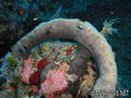
This 230 feet long vessel was built in Norway in 1954. It was intentionally sunk october 16, 1982. She now lays on her port side on a flat sandy floor, not far from few isolated coral banks.
English (Traduzir este texto em Português): This 230 feet long vessel was built in Norway in 1954. It was intentionally sunk october 16, 1982. She now lays on her port side on a flat sandy floor, not far from few isolated coral banks.
English (Traduzir este texto em Português): This 230 feet long vessel was built in Norway in 1954. It was intentionally sunk october 16, 1982. She now lays on her port side on a flat sandy floor, not far from few isolated coral banks.
English (Traduzir este texto em Português): This 230 feet long vessel was built in Norway in 1954. It was intentionally sunk october 16, 1982. She now lays on her port side on a flat sandy floor, not far from few isolated coral banks.
English (Traduzir este texto em Português): This 230 feet long vessel was built in Norway in 1954. It was intentionally sunk october 16, 1982. She now lays on her port side on a flat sandy floor, not far from few isolated coral banks.
English (Traduzir este texto em Português): This 230 feet long vessel was built in Norway in 1954. It was intentionally sunk october 16, 1982. She now lays on her port side on a flat sandy floor, not far from few isolated coral banks.
English (Traduzir este texto em Português): This 230 feet long vessel was built in Norway in 1954. It was intentionally sunk october 16, 1982. She now lays on her port side on a flat sandy floor, not far from few isolated coral banks.
 Comentários
Mostrar tudo (2)...
Erros, Reacções
Você pode editar esta página para corrigir os erros e acrescentar novas informações. Se você tem outros comentários sobre esta página, Envie as suas observações
Wannadive.net 24/24
Wannadive.net no seu telemóvel

Boletim Todas as notícias por e-mail
 Theo's Wreck

De Theo Galanopoulos , 14-05-2010
Theo (From Theo's Wreck) - I Like the plaque... Thanks