Perdeu a senha?
Novo usuário? Criar uma conta
Big eye, Philippines. Photo by Stephane Rochon.
Aprecie e contribua!
| Achar os melhores sites |
|
|
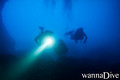
 Cueva del Morach
Spain, Costa Blanca, Alicante, Xabia
Este mapa é interactivo! Use os controles para fazer zoom ou para se deslocar.
|
Datum: WGS84 [ Auxílio ] |
Latitude: 38° 42.477' N |
Notação (2)
- Favoritos
-
Os seus sítios favoritos e as futuras listas de spots
Acesso
|
English (Traduzir este texto em Português): In the south end of the car parking in Playa de Moraig there´s a cave, the "Cueva de los Arcos" where you dive trough a tunnel to the open sea. Swim south, near the wall, until you find an entrance into a cave: that´s the Cueva del Morach, a subterranean river. Como? À partir da costa Distância Acesso directo Fácil de encontrar? Fácil de encontrar |
Características do local
Outro nome Cova de moraig
Profundidade média 10 m / 32.8 ft
Profundidade máxima 14 m / 45.9 ft
Correnteza Fraco ( < 1 nó)
Visibilidade Boa ( 10 - 30 m)
Qualidade
Qualidade do sitio Excelente
Experiência CMAS ** / AOW
Interesse bio Pobre
Mais detalhes
Cheio durante a semana
Cheio no fim de semana
Tipo de mergulho
- Gruta
Actividades de mergulho
- Espeleologia
Perigos
Informações suplementares
English (Traduzir este texto em Português): Attention: this dive can be very dangerous if you pass the entrance into the interior of the subterranean river. There the current is very strong.
The mix of sweat water with salt water is amazing.
Autor: Anónimo Contribuintes (1) Eles mergulharam neste spot! (9)
 Fotos
Fotos
Cueva del Morach |

Cueva del Morach |

Cueva del Morach |

Cueva del Morach |
Últimos mergulhos
|
Comentários
Seja o(a) primeiro(a) a fazer um comentário sobre este país
Erros, Reacções
Você pode editar esta página para corrigir os erros e acrescentar novas informações. Se você tem outros comentários sobre esta página, Envie as suas observações