Este mapa é interactivo! Use os controles para fazer zoom ou para se deslocar.
Acesso
|
English (Traduzir este texto em Português): Northeast of Halifax along the Marine Drive Hwy #7 is the community of Sheet Harbour. The habour splits into the main channel and an eat branch called East River. The tramp freighter ARCTIC TRADER caught fire twice at dockside on the large wharf. On the second time, she was cut free and ended up anchored out in front of the floating docks of a small yacht club, just south of the main wharf. Torpedo Rays Dive Shop has a good online write up for it, which led us to explore the spot. Take the righthand paved road shortly before crossing the large, green, steel East River Bridge. There is parking out of the way near the wharf and above the yacht club. Don't block the boat ramp.
English (Traduzir este texto em Português): Northeast of Halifax along the Marine Drive Hwy #7 is the community of Sheet Harbour. The habour splits into the main channel and an eat branch called East River. The tramp freighter ARCTIC TRADER caught fire twice at dockside on the large wharf. On the second time, she was cut free and ended up anchored out in front of the floating docks of a small yacht club, just south of the main wharf. Torpedo Rays Dive Shop has a good online write up for it, which led us to explore the spot. Take the righthand paved road shortly before crossing the large, green, steel East River Bridge. There is parking out of the way near the wharf and above the yacht club. Don't block the boat ramp.
Northeast of Halifax along the Marine Drive Hwy #7 is the community of Sheet Harbour. The habour splits into the main channel and an eat branch called East River. The tramp freighter ARCTIC TRADER caught fire twice at dockside on the large wharf. On the second time, she was cut free and ended up anchored out in front of the floating docks of a small yacht club, just south of the main wharf. Torpedo Rays Dive Shop has a good online write up for it, which led us to explore the spot. Take the righthand paved road shortly before crossing the large, green, steel East River Bridge. There is parking out of the way near the wharf and above the yacht club. Don't block the boat ramp.
English (Traduzir este texto em Português): Northeast of Halifax along the Marine Drive Hwy #7 is the community of Sheet Harbour. The habour splits into the main channel and an eat branch called East River. The tramp freighter ARCTIC TRADER caught fire twice at dockside on the large wharf. On the second time, she was cut free and ended up anchored out in front of the floating docks of a small yacht club, just south of the main wharf. Torpedo Rays Dive Shop has a good online write up for it, which led us to explore the spot. Take the righthand paved road shortly before crossing the large, green, steel East River Bridge. There is parking out of the way near the wharf and above the yacht club. Don't block the boat ramp.
English (Traduzir este texto em Português): Northeast of Halifax along the Marine Drive Hwy #7 is the community of Sheet Harbour. The habour splits into the main channel and an eat branch called East River. The tramp freighter ARCTIC TRADER caught fire twice at dockside on the large wharf. On the second time, she was cut free and ended up anchored out in front of the floating docks of a small yacht club, just south of the main wharf. Torpedo Rays Dive Shop has a good online write up for it, which led us to explore the spot. Take the righthand paved road shortly before crossing the large, green, steel East River Bridge. There is parking out of the way near the wharf and above the yacht club. Don't block the boat ramp.
English (Traduzir este texto em Português): Northeast of Halifax along the Marine Drive Hwy #7 is the community of Sheet Harbour. The habour splits into the main channel and an eat branch called East River. The tramp freighter ARCTIC TRADER caught fire twice at dockside on the large wharf. On the second time, she was cut free and ended up anchored out in front of the floating docks of a small yacht club, just south of the main wharf. Torpedo Rays Dive Shop has a good online write up for it, which led us to explore the spot. Take the righthand paved road shortly before crossing the large, green, steel East River Bridge. There is parking out of the way near the wharf and above the yacht club. Don't block the boat ramp.
English (Traduzir este texto em Português): Northeast of Halifax along the Marine Drive Hwy #7 is the community of Sheet Harbour. The habour splits into the main channel and an eat branch called East River. The tramp freighter ARCTIC TRADER caught fire twice at dockside on the large wharf. On the second time, she was cut free and ended up anchored out in front of the floating docks of a small yacht club, just south of the main wharf. Torpedo Rays Dive Shop has a good online write up for it, which led us to explore the spot. Take the righthand paved road shortly before crossing the large, green, steel East River Bridge. There is parking out of the way near the wharf and above the yacht club. Don't block the boat ramp.
English (Traduzir este texto em Português): Northeast of Halifax along the Marine Drive Hwy #7 is the community of Sheet Harbour. The habour splits into the main channel and an eat branch called East River. The tramp freighter ARCTIC TRADER caught fire twice at dockside on the large wharf. On the second time, she was cut free and ended up anchored out in front of the floating docks of a small yacht club, just south of the main wharf. Torpedo Rays Dive Shop has a good online write up for it, which led us to explore the spot. Take the righthand paved road shortly before crossing the large, green, steel East River Bridge. There is parking out of the way near the wharf and above the yacht club. Don't block the boat ramp.
English (Traduzir este texto em Português): Northeast of Halifax along the Marine Drive Hwy #7 is the community of Sheet Harbour. The habour splits into the main channel and an eat branch called East River. The tramp freighter ARCTIC TRADER caught fire twice at dockside on the large wharf. On the second time, she was cut free and ended up anchored out in front of the floating docks of a small yacht club, just south of the main wharf. Torpedo Rays Dive Shop has a good online write up for it, which led us to explore the spot. Take the righthand paved road shortly before crossing the large, green, steel East River Bridge. There is parking out of the way near the wharf and above the yacht club. Don't block the boat ramp.
Como? À partir da costa
Distância Acesso directo
Fácil de encontrar? Fácil de encontrar
|
|
Características do local
Profundidade média 4.6 m / 15.1 ft
Profundidade máxima 10.7 m / 35.1 ft
Correnteza Médio ( 1-2 nós)
Visibilidade Baixa ( < 5 m)
Qualidade
Qualidade do sitio Bom
Experiência CMAS ** / AOW
Interesse bio Interessante
Mais detalhes
Cheio durante a semana
Cheio no fim de semana
Tipo de mergulho
- Água doce
- Escombros de naufrágio
Actividades de mergulho
- Biologia Marinha
- Formação
- Fotografia
Perigos
- Correnteza
- Tráfego de barcos
- Redes
Informações suplementares
English (Traduzir este texto em Português): The top 2-3m is freshwater that has tannins in it, which makes it brown and dark. Below that is saltwater which increases with the tide cycle with a range of 2m. After diving the spot at low tide, I'd recommend just before high tide when more clearer saltwater covers the ship.
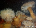
Going straight out from the boat ramp or the floating dock, you swim right into the bottom of the hull. the ship is bow to the left, down river, and is lying on its port side faced away from the shore. A nice route is up on the flank of the ship away from the very slity bottom; go right on top of the hull to the bow; then hop inside to go along the upper portion of the deck near the starboard railings. This way you can drop down onto the superstructure as you see it below you. On the ship there is little current, but up in the freshwater or on the surface, it can run 0.5 to 1.5 knots. Only properly trained and equipped divers should penetrate - all others stay outside and shinelights in the hatchways and windows. There are some lines, collapsing structures, and some netting so care is required moving along the ship. Railing in the saltwater are cloaked in sea anemones. Main lights, marker lghts and backup lights are recommended. Good buddy team work is essential to a fun safe dive.
We only dive this site outside of summer to reduce pleasure boat traffic - from October to April or May, divers will almost have the site to themselves.
English (Traduzir este texto em Português): The top 2-3m is freshwater that has tannins in it, which makes it brown and dark. Below that is saltwater which increases with the tide cycle with a range of 2m. After diving the spot at low tide, I'd recommend just before high tide when more clearer saltwater covers the ship.
Going straight out from the boat ramp or the floating dock, you swim right into the bottom of the hull. the ship is bow to the left, down river, and is lying on its port side faced away from the shore. A nice route is up on the flank of the ship away from the very slity bottom; go right on top of the hull to the bow; then hop inside to go along the upper portion of the deck near the starboard railings. This way you can drop down onto the superstructure as you see it below you. On the ship there is little current, but up in the freshwater or on the surface, it can run 0.5 to 1.5 knots. Only properly trained and equipped divers should penetrate - all others stay outside and shinelights in the hatchways and windows. There are some lines, collapsing structures, and some netting so care is required moving along the ship. Railing in the saltwater are cloaked in sea anemones. Main lights, marker lghts and backup lights are recommended. Good buddy team work is essential to a fun safe dive.
We only dive this site outside of summer to reduce pleasure boat traffic - from October to April or May, divers will almost have the site to themselves.
The top 2-3m is freshwater that has tannins in it, which makes it brown and dark. Below that is saltwater which increases with the tide cycle with a range of 2m. After diving the spot at low tide, I'd recommend just before high tide when more clearer saltwater covers the ship.
Going straight out from the boat ramp or the floating dock, you swim right into the bottom of the hull. the ship is bow to the left, down river, and is lying on its port side faced away from the shore. A nice route is up on the flank of the ship away from the very slity bottom; go right on top of the hull to the bow; then hop inside to go along the upper portion of the deck near the starboard railings. This way you can drop down onto the superstructure as you see it below you. On the ship there is little current, but up in the freshwater or on the surface, it can run 0.5 to 1.5 knots. Only properly trained and equipped divers should penetrate - all others stay outside and shinelights in the hatchways and windows. There are some lines, collapsing structures, and some netting so care is required moving along the ship. Railing in the saltwater are cloaked in sea anemones. Main lights, marker lghts and backup lights are recommended. Good buddy team work is essential to a fun safe dive.
We only dive this site outside of summer to reduce pleasure boat traffic - from October to April or May, divers will almost have the site to themselves.
English (Traduzir este texto em Português): The top 2-3m is freshwater that has tannins in it, which makes it brown and dark. Below that is saltwater which increases with the tide cycle with a range of 2m. After diving the spot at low tide, I'd recommend just before high tide when more clearer saltwater covers the ship.
Going straight out from the boat ramp or the floating dock, you swim right into the bottom of the hull. the ship is bow to the left, down river, and is lying on its port side faced away from the shore. A nice route is up on the flank of the ship away from the very slity bottom; go right on top of the hull to the bow; then hop inside to go along the upper portion of the deck near the starboard railings. This way you can drop down onto the superstructure as you see it below you. On the ship there is little current, but up in the freshwater or on the surface, it can run 0.5 to 1.5 knots. Only properly trained and equipped divers should penetrate - all others stay outside and shinelights in the hatchways and windows. There are some lines, collapsing structures, and some netting so care is required moving along the ship. Railing in the saltwater are cloaked in sea anemones. Main lights, marker lghts and backup lights are recommended. Good buddy team work is essential to a fun safe dive.
We only dive this site outside of summer to reduce pleasure boat traffic - from October to April or May, divers will almost have the site to themselves.
 Comentários
Mostrar tudo (0)...
Seja o(a) primeiro(a) a fazer um comentário sobre este país
Erros, Reacções
Você pode editar esta página para corrigir os erros e acrescentar novas informações. Se você tem outros comentários sobre esta página, Envie as suas observações
 Arctic Trader shipwreck