Este mapa é interactivo! Use os controles para fazer zoom ou para se deslocar.
Acesso
|
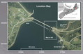
English (Traduzir este texto em Português): The Grand Narrows dive site is accessed from Highway 223. Thee site is approximately 62 km from Sydney or 25 km from the Trans Canada via Little Narrows. An entrance through the guard rail is positioned 0.3 km east of the car drawbridge; parking is at the beach.
English (Traduzir este texto em Português): The Grand Narrows dive site is accessed from Highway 223. Thee site is approximately 62 km from Sydney or 25 km from the Trans Canada via Little Narrows. An entrance through the guard rail is positioned 0.3 km east of the car drawbridge; parking is at the beach.
The Grand Narrows dive site is accessed from Highway 223. Thee site is approximately 62 km from Sydney or 25 km from the Trans Canada via Little Narrows. An entrance through the guard rail is positioned 0.3 km east of the car drawbridge; parking is at the beach.
English (Traduzir este texto em Português): The Grand Narrows dive site is accessed from Highway 223. Thee site is approximately 62 km from Sydney or 25 km from the Trans Canada via Little Narrows. An entrance through the guard rail is positioned 0.3 km east of the car drawbridge; parking is at the beach.
English (Traduzir este texto em Português): The Grand Narrows dive site is accessed from Highway 223. Thee site is approximately 62 km from Sydney or 25 km from the Trans Canada via Little Narrows. An entrance through the guard rail is positioned 0.3 km east of the car drawbridge; parking is at the beach.
English (Traduzir este texto em Português): The Grand Narrows dive site is accessed from Highway 223. Thee site is approximately 62 km from Sydney or 25 km from the Trans Canada via Little Narrows. An entrance through the guard rail is positioned 0.3 km east of the car drawbridge; parking is at the beach.
English (Traduzir este texto em Português): The Grand Narrows dive site is accessed from Highway 223. Thee site is approximately 62 km from Sydney or 25 km from the Trans Canada via Little Narrows. An entrance through the guard rail is positioned 0.3 km east of the car drawbridge; parking is at the beach.
English (Traduzir este texto em Português): The Grand Narrows dive site is accessed from Highway 223. Thee site is approximately 62 km from Sydney or 25 km from the Trans Canada via Little Narrows. An entrance through the guard rail is positioned 0.3 km east of the car drawbridge; parking is at the beach.
English (Traduzir este texto em Português): The Grand Narrows dive site is accessed from Highway 223. Thee site is approximately 62 km from Sydney or 25 km from the Trans Canada via Little Narrows. An entrance through the guard rail is positioned 0.3 km east of the car drawbridge; parking is at the beach.
Como? À partir da costa
Distância Acesso directo
Fácil de encontrar? Fácil de encontrar
|
|
Características do local
Outro nome Kaleva Wreck
Profundidade média 10.1 m / 33.1 ft
Profundidade máxima 20.1 m / 65.9 ft
Correnteza Médio ( 1-2 nós)
Visibilidade Média ( 5 - 10 m)
Qualidade
Qualidade do sitio Normal
Experiência CMAS * / OW
Interesse bio Interessante
Mais detalhes
Cheio durante a semana
Cheio no fim de semana
Tipo de mergulho
- Correntezas
- Escombros de naufrágio
Actividades de mergulho
- Biologia Marinha
- Orientação
- Fotografia
Perigos
- Correnteza
- Tráfego de barcos
Informações suplementares
English (Traduzir este texto em Português): Divers unfamiliar with the site should travel with a guide due to potential strong currents, depth, boat traffic, fish that like to nip at unwary divers, and the maze of underwater structures.
The dive site is best known for the abundance of marine life and the wreck that lies only 200 ft from the beach. Research conducted by the Baddeck Barnacles Diving Society in 2014 concluded that the reek is the final resting place of the Zealandia. The ship was built as a 3 masted, full-rigged clipper with an iron hull (No. 60969) by C. Connell and Co. in Glasgow in 1869. From 1870-1902 she served as a passenger/cargo ship for the Shaw, Savill and Albion Line of London, carrying over 4000 immigrants to New Zealand. Sold several times between 1902 and 1911 she was renamed Kaleva in 1907. Wrecked on Pumpkin Island Nova Scotia in 1911 she was salvaged and converted to a barge by Charles Brister of Halifax. In July 1916 she broke tow during a gale and sank after crashing into the Barra Strait railway bridge with a load of dolomite bound for Sydney. The wreck is 220 ft long by 40 ft wide and at the stern, it rises 30 ft off the bottom. At the wreck the maximum depth is 68 ft. Note because the wreck had been converted to a barge; most of upper deck structure was removed providing access to the inside of the bath tub like hull. Divers are advised however to avoid swimming under the remaining deck framing as the pieces could be loose. To aid getting on the wreck a rope is usually in place, extending from the beach to train swing bridge pivot support.
Although the wreck is the main attraction other structures merit exploration. A submerged wooden cribbed wharf extending approximately 300 ft to the south and parallel to the boat channel offers wall diving with depths ranging from 15 to 70 feet. Current most be considered here, but with careful planning this Site can make a terrific drift dive.
Divers unfamiliar with the site should travel with a guide due to potential strong currents, depth, boat traffic, fish that like to nip at unwary divers, and the maze of underwater structures.
The dive site is best known for the abundance of marine life and the wreck that lies only 200 ft from the beach. Research conducted by the Baddeck Barnacles Diving Society in 2014 concluded that the reek is the final resting place of the Zealandia. The ship was built as a 3 masted, full-rigged clipper with an iron hull (No. 60969) by C. Connell and Co. in Glasgow in 1869. From 1870-1902 she served as a passenger/cargo ship for the Shaw, Savill and Albion Line of London, carrying over 4000 immigrants to New Zealand. Sold several times between 1902 and 1911 she was renamed Kaleva in 1907. Wrecked on Pumpkin Island Nova Scotia in 1911 she was salvaged and converted to a barge by Charles Brister of Halifax. In July 1916 she broke tow during a gale and sank after crashing into the Barra Strait railway bridge with a load of dolomite bound for Sydney. The wreck is 220 ft long by 40 ft wide and at the stern, it rises 30 ft off the bottom. At the wreck the maximum depth is 68 ft. Note because the wreck had been converted to a barge; most of upper deck structure was removed providing access to the inside of the bath tub like hull. Divers are advised however to avoid swimming under the remaining deck framing as the pieces could be loose. To aid getting on the wreck a rope is usually in place, extending from the beach to train swing bridge pivot support.
Although the wreck is the main attraction other structures merit exploration. A submerged wooden cribbed wharf extending approximately 300 ft to the south and parallel to the boat channel offers wall diving with depths ranging from 15 to 70 feet. Current most be considered here, but with careful planning this Site can make a terrific drift dive.
English (Traduzir este texto em Português): Divers unfamiliar with the site should travel with a guide due to potential strong currents, depth, boat traffic, fish that like to nip at unwary divers, and the maze of underwater structures.
The dive site is best known for the abundance of marine life and the wreck that lies only 200 ft from the beach. Research conducted by the Baddeck Barnacles Diving Society in 2014 concluded that the reek is the final resting place of the Zealandia. The ship was built as a 3 masted, full-rigged clipper with an iron hull (No. 60969) by C. Connell and Co. in Glasgow in 1869. From 1870-1902 she served as a passenger/cargo ship for the Shaw, Savill and Albion Line of London, carrying over 4000 immigrants to New Zealand. Sold several times between 1902 and 1911 she was renamed Kaleva in 1907. Wrecked on Pumpkin Island Nova Scotia in 1911 she was salvaged and converted to a barge by Charles Brister of Halifax. In July 1916 she broke tow during a gale and sank after crashing into the Barra Strait railway bridge with a load of dolomite bound for Sydney. The wreck is 220 ft long by 40 ft wide and at the stern, it rises 30 ft off the bottom. At the wreck the maximum depth is 68 ft. Note because the wreck had been converted to a barge; most of upper deck structure was removed providing access to the inside of the bath tub like hull. Divers are advised however to avoid swimming under the remaining deck framing as the pieces could be loose. To aid getting on the wreck a rope is usually in place, extending from the beach to train swing bridge pivot support.
Although the wreck is the main attraction other structures merit exploration. A submerged wooden cribbed wharf extending approximately 300 ft to the south and parallel to the boat channel offers wall diving with depths ranging from 15 to 70 feet. Current most be considered here, but with careful planning this Site can make a terrific drift dive.
 Comentários
Mostrar tudo (0)...
Seja o(a) primeiro(a) a fazer um comentário sobre este país
Erros, Reacções
Você pode editar esta página para corrigir os erros e acrescentar novas informações. Se você tem outros comentários sobre esta página, Envie as suas observações
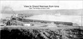
 Zealandia Wreck & Grand Narrows